Settlements > Petra
Petra
Background
Petra is an ancient trading city and the capital for the Nabataeans. The name Petra comes from the Latin word petrae, meaning rock. It was the center of their lucrative caravan trade and was lost to history until 1812 when it was discovered by Swiss explorers. The city itself was cut out of the rock and had an extensive water system that showed the sophistication of their empire.
The city is situated between the Red Sea and the Dead Sea, in present day Yemen south of the modern city of Amman. It was a center of trade for the rest of Arabia, Egypt and Phoenicia during the ancient past. The city itself is built into sandstone mountains that provided a great natural protection and allowed their trade based empire to flourish.
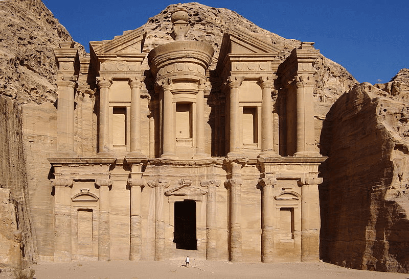
Petra Royal Treasury
The city of Petra still remains as elusive as it always has been in terms of yielding true knowledge about the People that built the city. They did not leave elaborate inscriptions like the Egyptians and archaeologists have still only uncovered about one percent of the entire site.
Conquered by both Alexander and the Great and the Roman Empire and flourished under both. However the city fell into decline as the trade routes they controlled became less popular and less frequently used. This led the descendants of the ancient Nabatean's to assimilate into the Roman Empire and distribute throughout its borders.
Origins
According to local legends, around 1,200 BC the area around Petra in Yemen was controlled by the Edomites and the area was known as Edom, which means red for the red sands that characterize the region. The Edomites controlled the trade routes between Arabia and Syria and it is not known weather they started or built the city of Petra or weather it was later groups that moved in. However, regardless the Edomites were a well known civilization in ancient that was renowned for their wisdom, writing, textiles, ceramics and metal working.
Nabataean Kingdom
The Edomites existed until the Nabateans invaded from the north and pushed them into modern day Palestine. The city of Petra was captured by the Nabateans in the 312 BC who were the remnants of Alexander the Great's Macedonian Empire. The Nabateans were a race of ancient arabic people that controlled a series of oasis's throughout the desert that would supply passing traders with food and shelter as they traveled from China to as far away as Egypt.
Due to this trade based empire there was a lot of cultural diffusion that occurred that brought about the characteristic Hellenistic Period. In Petra specifically there was a blending of Greek and Persian culture that prospered under the Seleucid Empire.
Not much is known about the Nabataeans as they did not leave many literary records nor did they leave any inscriptions on the inside of their buildings. Our best evidence for Petra comes from Pliny the Elder however it is also written about by Egyptians who accounted their military campaigns.
Regardless, given current archaeological evidence and the accounts of the past it was determined that the Nabataeans existed around 312-311 BC, right at the time of Alexander the Great. This was because it was written that the inhabitants of a city called Sela, the ancient name for Petra defended themselves against a Seleucid invasion.
The Selecuid's were eventually taken over by the Ptolemy's and the city of Petra fell under their dominion.
Mastery of Water
Like most of the cultures of ancient Mesopotamia, the Nabateans had a great mastery of water and infrastructure engineering that allowed them to create an extensive city in the middle of the desert. The Nabateans built a large network of tunnels, dams, cisterns and reservoirs which they used to collect as much rainwater during the rainy season. In fact, while these engineering feats allowed them to survive, they were also necessary for survival.
The rains that occurred in the winter would have the capability to develop into flash floods, with the possibility to devastate everything in their path.
Silk Road Trading
This ancient trading route was called the Silk Road and was responsible for the transmission of cultural ideas and influences from the East to the West. The Nabateans capital of Petra became a center for trade between Egypt, Maurya India and China. As you can see from the map, the kingdom of the Nabateans would be essential in transporting goods and persons across the barren desert of Arabia and Persia. It was situated in a prime location between Egypt and the rest of the world and what led to its prosperity.
There were many types of goods traded along the Silk Road. Bitumen from Egypt, silks from China, incense from Arabia and the spices of India were all traded within the mountainside fortress. Along with trade route salt was probably a key good as well. In fact, the Nabatean trade routes and suppliers were all regarded as basically state secrets according to historian Diodorus Siculus.
So the city was well defended and a very prosperous trading Empire for several centuries. It never really appeared to experience internal strife so what exactly happened to Petra?
Decline of Petra
At the height of its power Petra was annexed within the Roman Empire and given nearly autonomous status to continue their trading. They were to act more as a buffer state between the Roman Empire and the "barbarians" to the North.
Petra experienced a slow and prolonged collapse as the world found different trading routes and the Roman Empire grew. There was no longer a need for the city and the trading network and after being conquered it gradually became a part of Roman culture.
The Romans
The city of Petra was first conquered in 64-63 BC by the Romans under General Pompey. He set about on a practice to take the cities that were captured by the Jews. Once Petra was captured it was set up as more of an autonomous kingdom and a buffer state for the marauding tribes from the North. The Romans taxed it and left it to its own devices.
Next, Petra and its loosely connected oasis satellites was conquered by the Roman Trajen along with the entire Nabatean kingdom in 106 AD. It was integrated into the larger Arabia Petraea with its capital at Petra. The people and locations were assimilated into the Roman Empire where eventually they were lost for good as all Greco-Roman culture began to combine and like the Hellenistic Period before it, gave rise to a new unique identity.
Finally, the last real role Petra played in ancient society was under Emperor Hadrian. Upon his visiting the city, Hadrian renamed it Hadriane Petra after himself and the city continued to flourish. Tombs were still being built and the Triumphal Arch was built as well. Even despite the apparent success, the economics of the world had changed and Petra saw no place in the world's future.
It was during this period, that much like the Hellenistic one before, led to a blending of traditional Roman Classical monuments, with a little Nabatean influence thrown in. It is in this culture that the Nabatean's still survive to this day.
Christianity
The city of Petra survived until 313 AD, when Christianity became the official religion of the Roman Empire. When the Eastern Roman Empire was established in 330 AD by Emperor Constantine, Petra still remained a center of commerce and population. It was even the governmental seat of a later Byzantine bishopric leader.
In fact, current archaeology is actually revealing evidence of this as there are numerous papyrus scrolls that span the time period. It is also revealed that Christians and the still practicing pagans of the Roman Empire lived in peace and harmony with each other.
Destruction of Petra
The destruction and abandonment of Petra was two pronged. While it was physically devastated by a series of earthquakes that struck the region, it was actually on the decline way before these incidents occurred. Since the city was built on a trading network, when that trading network shifted the need for Petra wained. As the world entered the common era, the Silk Road faded and the world began to take on a new shape.
As less people would pass through, the residents would move onto more prosperous trading posts and gradually Petra would have been left to the sands.
Earthquakes
A major earthquake struck in 363 BC that destroyed half of the city. Regardless of this, Petra still continued to flourish throughout the history of the Roman Empire. In fact, the previously discussed papyrus scrolls date from the 6th century AD.
During this period, considering half of the city was destroyed, the locals built churches and other monuments from the remains of the collapsed city. The recently excavated Petra Church is a great example of this as well as the beautiful mosaics that adorned the walls.
Regardless of the earthquakes, Petra was already on the decline as the global trading routes began to change. Since the entire city was built on mastery of water and trading, an innovation in trade routes would also bring about the decline of Petra.
Abandonment
Next, in 551 AD, another even more devastating earthquake devastated the city and brought the sandstone mountains crashing down. As Islam began to rise during this period the city lost its prominence and was eventually conquered.
The Arabs conquered Petra in 636 AD but it was not as well connected to the Empire because it lie past Mecca. It was later taken briefly by the crusaders in the 12th century AD and rebuilt to its original glory. It was only occupied by the crusaders for a few years before they moved on and left Petra to the local people.
Re-Discovery
Petra was discovered by Swiss explorer Johann Ludwig Burckhardt in 1812. After his initial documentation many explorers, archaeologists and adventurers came to the city to marvel at its ancient beauty. In fact Petra was reviewed by Libbey and Hoskins in 1905, one of the first documented articles regarding the site.
After the site was documented in print it began to draw the attention of academics and scholars who wished to study and excavate the site. A. Musil published the first archaeological dig at the site in Arabia Petraea in 1907.
Modern Era
Petra was surveyed again in the 1920's by R. E. Brünnow and A. von Domaszewski. These two archaeologists greatly explored the Great Temple structure of Petra. They published their results in Die Provincia Arabia. This survey has formed the basis for the archaeological work done at Petra until 1990 where it was picked up by Judith McKenzie.
Another excavation by P. J. Parr and C. M. Bennett in 1958 of the British School of Archaeology is one of the best and most accurate archaeological digs done at the site.
Present Day
There have been many modern day attempts to preserve and study the ancient ruins of Petra. The site is constantly threatened by the increased amounts of tourism since articles started appearing in the Smithsonian and other media.
The Jordanian Department of Antiquities has undertaken the Petra/Jerash Project along with the University of Jordan, the University of Utah and Swiss archaeologists have all begun excavations at the massive amount of sites in and around the city of Petra.
Currently, archaeologists have only examined a fraction of the buried material but despite this the ruins that have been excavated are a site to behold. After 100 years of investigations and digs only one percent of the city remains uncovered.
Structures & Artifacts
There exists many beautiful structures and artifacts at Petra, and more are constantly being uncovered as archaeologists and scholars work tirelessly to decipher the mystery of the Nabataeans and their mountainside stronghold.
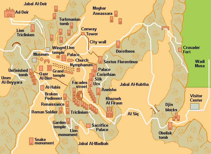
Petra Structures Map
As we uncover more of the ancient Nabataeans culture we will gain a better understanding of where this city came from and who built it originally. When talking about a city like Petra it is hard to understand what the original site may have looked like since it was built so much upon by Alexander the Great and the following Hellenistic culture along with the Romans and the Crusaders.
Colonnade Street
The Colonnade Street is what connects all of the outlying structures and the central city of Petra.
Great Temple
One of the first uncovered structures of Petra was the Great Temple. This was discovered by Brünnow and von Domaszewski but he did not originally know what it was. It was Bachmann who realized that the structure was a Great Temple and was aligned with the Colonnade Street.
Another broad monumental stairway led to a second, Upper Temenos. At its center was the temple, with yet another flight of stairs leading into the temple proper. While no standing structures were revealed before these excavations, the site is littered with architectural fragments, including column drums, probably toppled by one of the earthquakes which rocked the site. Given the promise of the Great Temple precinct and its importance in understanding Petra’s architectural and intercultural history, it is remarkable that it remained unexcavated until 1993 when the Brown University investigations began.North from the Khazneh lies the massif of Jebel Khubtha. Three large structures (Royal Tombs) are carved into the rock face, which is known as the King's Wall.First is the Urn Tomb, a well-preserved monument that faces on to an open terrace fronted by a double row of vaults. A colonnaded cloister runs along the northern side of the terrace. The elaborate facade fronts a single, unadorned room. The walls are smooth, the interior corners exact. The only decoration to be seen at present comes from the beautiful whorls of different-coloured sandstone in the walls, ceiling and floor of the chamber.The Corinthian Tomb, a smaller version of the Khazneh, is followed by the Palace Tomb (Silk Tomb), named from the extraordinary chromatic effect of the rock.Some distance away from the Royal Tombs, to the north, there is a tomb built in 130 for the Roman governor of the city under Hadrian, Sextius Florentinus.The Khazneh el Faroun, or the Treasury of the Pharaoh, is an imposing facade standing some 40 m tall, cut directly from the rock of the mountainside. On the lower floor is a portico with six columns, crowned by floral capitals and surmounted by a fronton; the third floor is divided into three parts at the centre is a tholos with a conical roof, surmounted by a urn, and on either side two half-frontons, supported by columns.An architectural and sculptural decoration of the highest quality adorns the architecture elements and the front of the building. The Khazneh is the only rock-cut building in Petra that presents absolutely no Nabataean element and attests to link exclusively with the Alexandrian world and Hellenistic artistic traditions. Behind the impressive facade, a large square room has been carved out of the rock of the cliff. This is typical of the tombs in Petra; the interiors are as plain as the exteriors are intricate.The Siq is the gorge formed by the torrent, the Musa, which the Nabataeans blocked with a dam and channelled to carry drinking water to the city; along the rock walls of the Siq there is a succession of inscriptions, niches and small votive altars, but also reliefs and sculptures that depict a caravan of men and camels.Once inside, the Siq narrows to little more than 5 m in width, whereas the walls tower up hundreds of metres on either side. The floor, originally paved, is now largely covered with soft sand, although evidence of Nabataean construction can still be seen in some places.There are also noteworthy relics from Roman times: at the southern edge of the valley stands the 1st century AD theatre, carved almost entirely in the rock, which could hold more than 8,000 spectators, while at the end of the Siq the ruins open out of the colonnaded way.Set on a promontory that overlooks the valley of Petra to the west, accessible via a type of sacred stepped way cut into the rock, is another building with an imposing facade carved out of the rock: this is al-Dayr, the austerity and the simplicity of which join to demonstrate the original local version of elements of the Hellenistic tradition. The structure of the interior is devoid of any funeral installation.